July 30, 2021
Skylark Wide-Area Corrections Expand to Japan
Swift Navigation of San Francisco and Tokyo-based KDDI Corporation, a telecommunications company have partnered to bring precise positioning to the Japanese market.
By Inside GNSSGlobal Navigation Satellite Systems Engineering, Policy, and Design
Swift Navigation of San Francisco and Tokyo-based KDDI Corporation, a telecommunications company have partnered to bring precise positioning to the Japanese market.
By Inside GNSS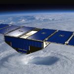
NASA has awarded a contract to the University of Michigan for the Cyclone Global Navigation Satellite System (CYGNSS) for mission operations and closeout. A constellation of eight microsatellites, the system can view storms more frequently and in a way traditional satellites are unable to, increasing scientists’ ability to understand and predict hurricanes. The total value of the contract is approximately $39 million. The CYGNSS Science Operations Center is located at the University of Michigan.
By Inside GNSS
In a demonstration of new services that NextGen TV can offer, BitPath, CAST.ERA and ONE Media publicly trialed “Enhanced GPS” broadcasts that could provide a tool for autonomous vehicle navigation and other applications.
By Inside GNSS
The Trimble GuidEx Machine Guidance System uses an integrated GNSS and inertial navigation system (INS) to compute a virtual reference point and precise heading, pitch and roll. This provides quick and efficient navigation along route corridors or to specific target areas,
By Inside GNSS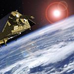
The European GNSS Agency (GSA) awarded a 1 million-euro research contract to RUAG Space for a study to increase the accuracy of space data provided by climate and environmental satellites.
By Inside GNSS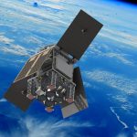
HydroGNSS, a small satellite built and operated by Surrey Satellite Technology Ltd, will measure Earth’s climate variables using GNSS reflectometry.
By Inside GNSS
eMobility services that provide on-demand eBikes and eScooters rentals are fast growing alternatives to traditional transportation modalities. As they are affordable, convenient, and very green, eMobility services will continue to grow in popularity. This article presents some of the challenges and useful solutions to accurately track eBike and eScooter location in the real world.
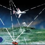
The Department of Transportation (DOT) submitted its “National Timing Resilience and Security Act: Roadmap to Implementation” report to Congress in mid-January. Following a competitive application process, demonstrations and review of 11 candidate technologies to back up GPS capabilities, the DOT concluded that “none of the systems can universally backup the positioning and navigations capabilities provided byGPS and its augmentations.” However, “all vendors demonstrated some PNT performance of value, but only one vendor, NextNav, demonstrated in all applicable use case scenarios.”
By Inside GNSS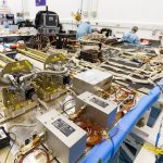
According to a statement on the UK Government’s official website, as of January 1 the United Kingdom will cease participation in the European Galileo and European Geostationary Navigation Overlay Service(EGNOS) programs. British citizens and other private users are not affected, apparently: “devices that currently use Galileo and EGNOS, such as smart phones, will continue to be able to do so.”
By Inside GNSS
The GNSS User Technology Report 2020 from the European GNSS Agency (GSA) analyzes the latest GNSS trends and developments as the GNSS industry broadly adopts multifrequency receivers across market segments.
By Inside GNSS
A satellite launching in November will use GNSS – Radio Occultation (GNSS-RO) to collect highly accurate global temperature and humidity information as an aid to more accurate and more advanced weather forecasting. Developed by NASA’s Jet Propulsion Laboratory (JPL), the spacecraft’s GNSS-RO instrument tracks GNSS satellite signals to measure the physical properties of Earth’s atmosphere.
By Inside GNSS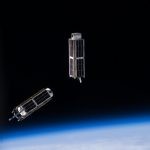
Hundreds, thousands of tiny satellites no bigger than a breadbox orbit the Earth, gathering a staggering amount of data and relaying petabytes of communication. These nanosatellites, commonly called cubesats, serve a variety of research and, increasingly, commercial roles. They work for science, exploration, technology development, education, telecommunications and other operations.
They are built to a standard dimension of 10 cm x 10 cm x 10 cm, or small multiples thereof. Typical weight is less than 1.33 kg (3 lbs) per U, or Unit, which equals on 10 cm cube.
Among other launch opportunities, the National Aeronautics and Space Administration’s (NASA’s) CubeSat Launch initiative (CSLI) can give a ride up to small satellites as auxiliary payloads on planned rocket missions.
To meet performance requirements, commercial cubesats must often report from a precisely known location. Faulty positioning can produce inaccurate data that will adversely affect commercial operations on Earth. Cubesats typically carry a commercial GPS L1 receiver to determine their orbit, as altitude and orbit determination and control form key parameters.
Cubesats often fly in formation and wil then use a GPS/GNSS receiver to co-ordinate and synchronize among themselves. Finally, they use GNSS for onboard synchronization of operations and for precise timestamping of Earth observation data
Though small is size, cubesats can carry a large price tag, up to hundreds of thousands of dollars per project. Pre-launch testing for quality assurance is critical, particular of the satellites’ PNT capabilities. Earth-bound testing cannot replicate the conditions of low-Earth orbit, where the satellites will be moving at several kilometers per second, and need to maintain awareness of the also moving GNSS satellites above them in mid-Earth orbit. Thus the key role of GNSS simulation in this burgeoning industry.
The content of this article is largely drawn from a blog post by Talini Pinto Jayawardena, a space science technologist with Spirent Communications, and also a research manager at the University of Bath. To read her full blog, which contains a detailed description of key performance criteria to test with a simulator, visit here.
Extensive discussion of Doppler shift handling, precise orbit determination, antenna performance, time synchronization, special events, onboard interference handling, and the impact of environmental test (vibration and thermal vacuum) is presented.
By Inside GNSS

Location intelligence software-maker Esri will provides free access to its ArcGIS platform and learning resources to support college and university students who no longer have access to campus computer labs during the COVID-19 outbreak. Access is through the Learn.ArcGIS.com website.
By Inside GNSS